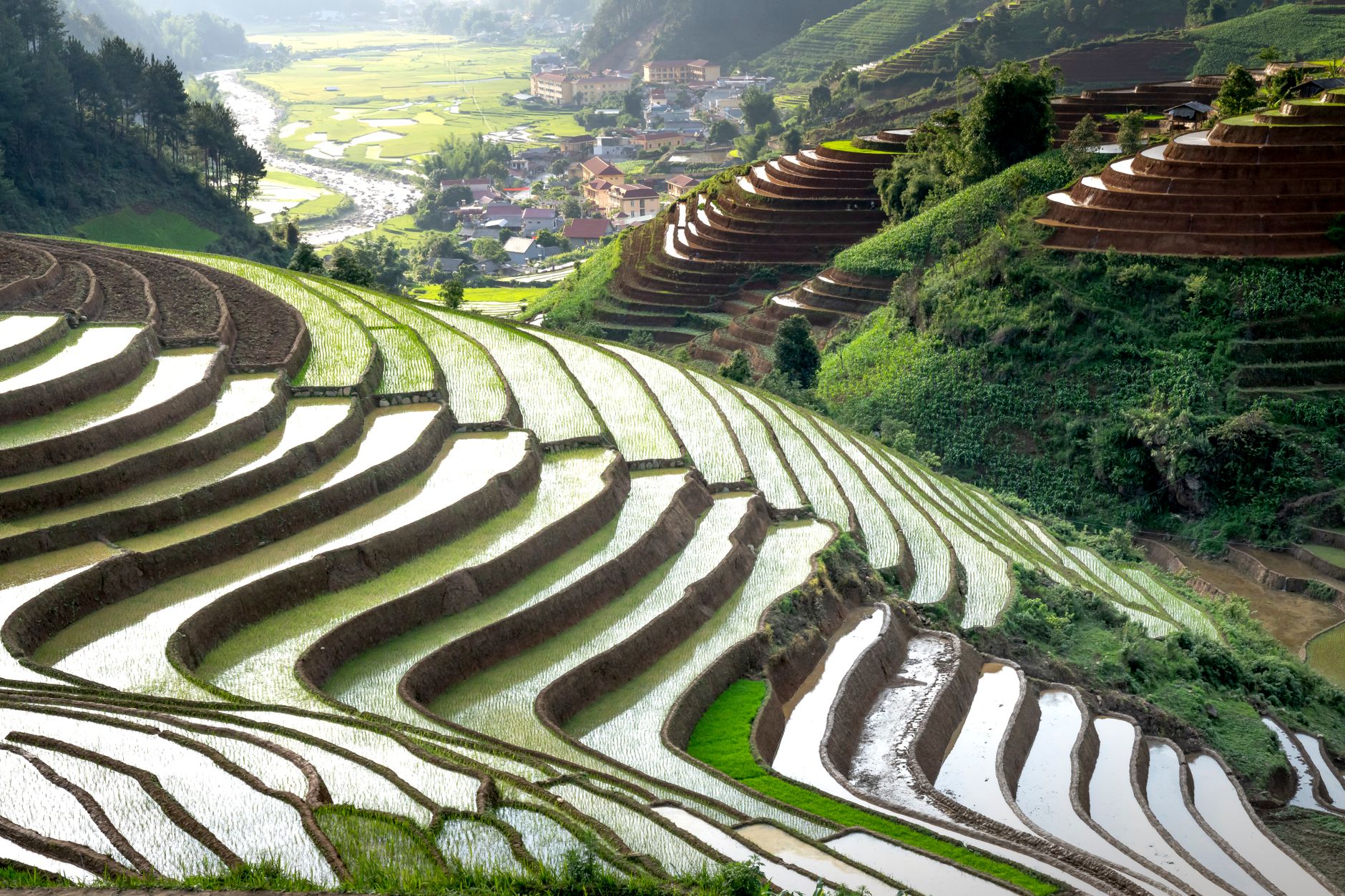
This is not the Ha Giang Loop. There are no backpacker hostels every 20 kilometers, no "loop parties," no English menus on every corner. The Sapa-Mu Cang Chai route is quieter, rougher, and arguably more beautiful in its rice terrace scenery. It rewards those who plan carefully and move with the seasons.
Route logistics: how the loop actually works
The loop connects three main points: Sapa, Than Uyen, and Mu Cang Chai. Most travelers start in Sapa because it has the best transport connections from Hanoi. From there, the route heads south on the QL4D toward Lai Chau, then east on the QL32 through Than Uyen before climbing over the Khau Pha Pass into Mu Cang Chai.
The full driving distance is roughly 450 kilometers if you return to Sapa, or about 280 kilometers one-way if you continue to Nghia Lo and then toward Hanoi. The road quality varies dramatically. The QL4D and QL32 are paved but narrow, with frequent landslides during rainy season. The TL163 from Than Uyen to Mu Cang Chai is the roughest stretch, with potholes and loose gravel in places.
| Segment | Distance | Driving time | Road condition |
|---|---|---|---|
| Sapa to Lai Chau (QL4D) | 65 km | 2-2.5 hours | Paved, winding, frequent buses |
| Lai Chau to Than Uyen (QL32) | 75 km | 2.5-3 hours | Paved, some rough patches |
| Than Uyen to Mu Cang Chai (TL163) | 55 km | 2-3 hours | Rough, gravel sections, steep |
| Mu Cang Chai to Nghia Lo (QL32) | 80 km | 2.5 hours | Paved, good condition |
| Nghia Lo to Hanoi | 180 km | 5-6 hours | Paved highway, heavy truck traffic |
The loop makes most sense as a one-way journey. Start in Sapa, ride to Mu Cang Chai, then continue to Nghia Lo and catch a bus back to Hanoi. Returning to Sapa by the same road wastes a day and repeats scenery. For those with limited time, ending in Hanoi saves the 6-hour train ride back from Sapa.
Best timing: rice terrace seasons and weather windows
The rice terraces around Sapa and Mu Cang Chai follow a strict agricultural calendar. Getting the timing right determines whether you see flooded mirrors reflecting the sky, bright green shoots, or golden fields ready for harvest.
The flooding season runs from late May through mid-June. Farmers release water into the terraces to soften the soil before planting. This is when the terraces become giant mirrors, each one catching the light differently as the sun moves across the valley. The water level peaks around the first two weeks of June.
The green season lasts from late June through August. The rice grows rapidly, painting the hillsides in vivid shades of green. This period sees more rain and cloud cover, but the landscape is lush and the crowds are thinner.
The golden season runs from mid-September through early October. The rice ripens and the terraces turn gold. This is the most photographed period, and for good reason. The combination of golden fields, morning mist, and clear autumn skies is unmatched. Harvest typically begins in late September at lower elevations and continues into October at higher altitudes.
Pro tip: For golden season, aim for the last week of September. The lower terraces near Mu Cang Chai ripen first, while higher areas near Sapa follow about two weeks later. This means you can catch different stages of the harvest along the route.
Weather is the other variable. The region experiences heavy rain from June through August, with typhoon remnants occasionally causing landslides. The rainy season in Vietnam peaks in July and August, making the rougher sections of the loop difficult or dangerous. October offers the most stable weather after the monsoon retreats, with clear mornings and cool temperatures ranging from 15-25°C.
For a full breakdown of monthly conditions, check the detailed 12-month reference guide before booking.
Motorbike versus bus: the honest comparison
Motorbike self-drive gives the most freedom. The route is well-marked, and the scenery changes around every bend. Rental costs run 200,000-350,000 VND ($8-14) per day for a semi-automatic Honda Blade or similar. Fuel for the full one-way journey costs around 150,000 VND ($6). The main expense is the bike itself, which can be dropped off in Hanoi for an additional fee of 500,000-1,000,000 VND ($20-40) depending on the rental company.
The catch is experience. The mountain roads are narrow, blind corners are common, and trucks use the QL32 frequently. Rain makes the surface slick. First-time riders should consider the legal and safety realities of renting a motorbike in Vietnam before committing.
Easy rider options solve this problem. Local riders with experience on these roads take you as a passenger on the back of their bike. Rates run 800,000-1,200,000 VND ($32-48) per day including the bike, fuel, and guide. This is the safest option for those who want the experience without the risk. Many easy riders speak basic English and know the best viewpoints and homestays along the route.
Bus travel works but limits flexibility. Public buses run from Sapa to Lai Chau and from Nghia Lo to Mu Cang Chai, but connections are infrequent. The section between Than Uyen and Mu Cang Chai has no direct bus service. Travelers using public transport must piece together multiple rides, often waiting hours for connections. Private transfers cost 2,500,000-4,000,000 VND ($100-160) for the full one-way route with stops.
For most travelers, the motorbike option wins. The loop is short enough that self-driving is feasible, and the scenery demands the freedom to stop anywhere.
Days needed: three, four, or five
Three days is the minimum. Day one covers Sapa to Than Uyen or Mu Cang Chai directly, day two explores the terraces around Mu Cang Chai, and day three rides to Nghia Lo for the bus to Hanoi. This schedule allows roughly 4-5 hours of riding per day, leaving time for photo stops and short walks but not much else.
Four days is the sweet spot. Add a day for a proper trek through the terraces around Mu Cang Chai, visiting villages like La Pan Tan or Che Cu Nha. This also allows for a detour to the Khau Pha Pass viewpoint and time to relax at a homestay without rushing.
Five days suits those who want to include a market day or deeper cultural immersion. The region hosts several rotating markets where H'Mong and Red Dao communities gather to trade. Check the local calendar before planning, as these markets run on a six-day cycle. A five-day schedule also provides buffer for weather delays, which matter during the rainy season.
Pro tip: The H'Mong culture in Vietnam guide covers the market schedules and homestay etiquette in detail. Read it before choosing which day to arrive.
Where to stay along the route
Sapa offers the widest range of accommodation, from budget hostels to luxury resorts with mountain views. The town itself is touristy, but the surrounding valleys provide quieter options. For a more authentic experience, stay in a homestay in Ta Van or Lao Chai villages, a short drive from town.
Than Uyen is a functional stopover rather than a destination. It has basic guesthouses and a few local restaurants. The main reason to stay is to break up the ride between Lai Chau and Mu Cang Chai. The town sits in a wide valley with rice fields on all sides, pleasant but unremarkable.
Mu Cang Chai is the highlight. The town itself is small, but the surrounding communes of La Pan Tan, Che Cu Nha, and De Xu Phinh contain the most spectacular terraces in Vietnam. Homestays in these villages offer basic rooms with shared bathrooms, family meals, and the chance to see daily life unfold. Prices range from 150,000-300,000 VND ($6-12) per night including meals.
The Red Dao culture page covers the herbal bath experience that many homestays offer. It is worth trying after a long day of riding.
Trekking and viewpoints around Mu Cang Chai
The terraces around Mu Cang Chai are best explored on foot. Several established trekking routes connect the villages, ranging from 2-hour walks to full-day hikes. The most popular route starts at La Pan Tan and climbs to a viewpoint overlooking the famous "rice field staircase" that appears on most Vietnam tourism posters.
The Khau Pha Pass, located between Mu Cang Chai and Nghia Lo, offers the most dramatic road viewpoint. At 1,500 meters elevation, the pass looks down over a valley filled with terraces that stretch to the horizon. The best light comes in the early morning when mist fills the valleys below.
For those interested in longer treks, the trekking in Vietnam itinerary includes Mu Cang Chai as a core stop. It pairs well with Pu Luong for a two-week northern adventure.
Pro tip: Hire a local guide for half-day treks around Mu Cang Chai. Guides cost 300,000-500,000 VND ($12-20) and know which paths are passable after rain. They also provide access to villages that are not on the main tourist route.
Food along the loop
The food in this region differs from the rest of Vietnam. The cuisine is influenced by the H'Mong and Thai communities who dominate the population. Expect hearty dishes built around mountain vegetables, river fish, and locally raised pork.
Thang co is the most famous local dish, a stew made from horse meat and offal, cooked for hours with mountain herbs. It is an acquired taste and not for the faint of heart, but it appears at every market and festival.
Lam rice is sticky rice cooked inside bamboo tubes over an open fire. The rice absorbs the bamboo's fragrance and develops a slightly chewy texture. It is served with grilled meat or fish at most homestays.
Cap nach pork refers to pigs raised free-range in the mountains. The meat is denser and more flavorful than commercial pork. It is often grilled simply over charcoal and served with salt, chili, and lime.
For a broader introduction to northern Vietnamese food, the breakfast in Vietnam guide covers the morning staples found across the region. The north vs central vs south comparison explains how mountain cooking differs from the coastal traditions.
Practical concerns and safety
Fuel stations are sparse between Than Uyen and Mu Cang Chai. Fill up whenever the gauge drops below half. The distance between fuel stops can exceed 80 kilometers on some sections.
Mobile coverage exists along most of the route but drops in the valleys and passes. Download offline maps before leaving Sapa. The Grab app works in Sapa and Nghia Lo but not in the rural sections between them.
Landslides are a real risk during the rainy season. The QL32 and TL163 both pass through landslide-prone terrain. Check local conditions before setting out, and be prepared to turn back if roads are blocked. The rainy season guide has practical advice for navigating this.
Altitude sickness is unlikely at these elevations, but the cold is real. Temperatures at Khau Pha Pass can drop below 10°C even in summer. Pack layers.
Getting there and away
From Hanoi, the overnight train to Sapa remains the most comfortable option. The Hanoi to Sapa transport guide compares train, bus, and private car options with current prices. The train takes about 8 hours and arrives in Lao Cai, from where a 45-minute bus ride climbs to Sapa.
From Mu Cang Chai, the most practical exit is by bus to Nghia Lo, then onward to Hanoi. Buses run several times daily, and the journey takes 7-8 hours total. Alternatively, continue riding to Nghia Lo and arrange a motorbike transport service to return the bike to Hanoi.
For those continuing to other parts of Vietnam, the loop connects naturally to the northern Vietnam itinerary or the 3-week north-to-south route. The road from Nghia Lo continues south toward Mai Chau and Pu Luong, offering an alternative to returning to Hanoi.
FAQ
Q: How difficult is the motorbike ride between Sapa and Mu Cang Chai? The route is moderate difficulty. The roads are paved but narrow, with frequent blind corners and occasional rough patches. Riders with basic experience can handle it, but first-time riders should practice on easier roads first. The TL163 between Than Uyen and Mu Cang Chai is the most challenging section.
Q: Can the loop be done in 2 days? Technically yes, but it means 6-7 hours of riding per day with no time for trekking or village visits. The scenery deserves more time. Three days is the realistic minimum for a worthwhile trip.
Q: What is the best month for golden rice terraces? Late September through early October. The exact timing varies by elevation, with lower terraces ripening first. The last week of September offers the best combination of golden fields and stable weather.
Q: Are there ATMs in Mu Cang Chai? There are two ATMs in the town center, but they sometimes run out of cash on weekends. Withdraw enough in Sapa or Lai Chau before heading into the rural sections. Most homestays accept cash only.
Q: Is it safe to do the loop during the rainy season? The route is passable from June through August, but landslides can block sections temporarily. Check road conditions locally before departing each day. The rainy season travel guide has detailed advice.
Q: Do I need a guide for the trekking around Mu Cang Chai? Not for the main viewpoints near La Pan Tan, which have clear paths and signposts. For village-to-village treks or visits to remote communes, a local guide adds safety and cultural context. Guides cost 300,000-500,000 VND ($12-20) per half day.
Q: Can I do the loop by bicycle? Yes, but it is demanding. The route includes multiple passes exceeding 1,500 meters, and the rough sections on TL163 are difficult on a road bike. Mountain bikes or gravel bikes are essential. Budget 4-5 days for the one-way journey.