What is the Cao Bang Loop and why does it matter?
The Cao Bang Loop is a shorter, less crowded alternative to the Ha Giang Loop. It connects Cao Bang city to Ban Gioc Waterfall, Phong Nam Valley, and the mountain passes in between. Unlike the Ha Giang Loop, there is no single "official" loop. Instead, a network of routes can be combined into 2-4 day itineraries.
The key distinction: the Cao Bang Loop is not a loop in the circular sense. It is a series of out-and-back or point-to-point routes. You start in Cao Bang city, ride to Ban Gioc Waterfall, and either return the same way or take a different route through Phong Nam Valley and back.
Why does it matter? The Cao Bang Loop offers dramatic limestone karst scenery, fewer tourists, and lower costs than Ha Giang. The roads are generally well-paved. The views rival anything in northern Vietnam. And you can complete the essential route in two days.
For a deeper look at crowds and development, read our guide: Is Cao Bang touristy? An honest look at crowds, development, and what to expect in 2026.
Cao Bang Loop map overview: The three essential routes
Three core route options cover the best of the region. Choose based on your time and riding experience.
| Route | Distance | Days needed | Difficulty | Highlights | Best for |
|---|---|---|---|---|---|
| Route 1: Classic Loop | 170 km round trip | 2 days | Easy-moderate | Ban Gioc Waterfall, Nguom Ngao Cave, Phuc Sen village | Short trips, beginners |
| Route 2: Extended Loop | 220 km | 3 days | Moderate | Adds Phong Nam Valley, God's Eye, Thang Hen Lake | Most travelers |
| Route 3: Full Geopark Loop | 350+ km | 4 days | Hard | Adds Me Pia Pass, Nguyên Bình, remote villages | Experienced riders |
Route 1: The Classic Loop (Cao Bang city to Ban Gioc and back). This is the essential Cao Bang experience. 170 km round trip on fully paved roads. The elevation gain is gradual, not steep. Most riders complete it in 2 days with an overnight near the waterfall. The road is narrow in sections but manageable for riders with basic experience.
Route 2: The Extended Loop (adding Phong Nam Valley and God's Eye). This adds a detour through Phong Nam Valley after visiting Ban Gioc. The valley road is well-maintained with rice terraces and water buffalo. The God's Eye viewpoint requires a steep 500-meter walk up a gravel road. This route offers the best variety of scenery for the time invested.
Route 3: The Full Geopark Loop (including Me Pia Pass). This is the ambitious option. It covers the entire Non Nuoc Cao Bang Geopark. Me Pia Pass is 2-3 hours from Ban Gioc on winding but paved roads. The famous "slinky road" viewpoint requires a 30-minute hike from a small parking area. This route is best for riders with at least 6 months of experience on Vietnamese roads.
For a detailed safety assessment, see: Is the Cao Bang Loop safe to drive?.
How to get to Cao Bang: Starting your loop
Cao Bang city is the starting point for all routes. Here are your options for getting there.
From Hanoi: Sleeper buses run daily. The journey takes 6-9 hours. Tickets cost 250,000-500,000 VND ($10-20 USD). The "limousine" buses with reclining seats and legroom are worth the extra cost. Buses depart from My Dinh or Giap Bat bus stations. Book through your hotel or a reputable bus company. Trains do not serve Cao Bang.
From Ha Giang: A direct bus takes 4-5 hours. Tickets cost 150,000-250,000 VND ($6-10 USD). This is the best option if you plan to combine the Cao Bang Loop with the Ha Giang Loop. For more on getting to Ha Giang, read: Hanoi to Ha Giang: 3 Routes Compared (Sleeper Bus, Limousine Van, Private Car).
From Sapa: No direct route exists. You must go via Hanoi or take a bus to Lao Cai, then a train to Hanoi, then a bus to Cao Bang. This takes 12+ hours. Consider doing Cao Bang first or last in your itinerary.
By private car: Available from Hanoi for 2,500,000-4,000,000 VND ($100-165 USD) one way. This is the most comfortable option but significantly more expensive.
Getting around the loop: Motorbike vs. car vs. easy rider
Three transport options exist for the loop. Each suits different traveler profiles.
| Mode | Cost per day | Skill required | Comfort | Flexibility | Best for |
|---|---|---|---|---|---|
| Self-drive motorbike | 150,000-200,000 VND ($6-8 USD) | Intermediate+ | Low | High | Experienced riders |
| Car rental with driver | 800,000-1,200,000 VND ($33-50 USD) | None | High | Medium | Groups, non-riders |
| Easy rider | 500,000-800,000 VND ($20-33 USD) | None | Medium | Medium | Solo travelers, beginners |
Self-drive motorbike. Best for experienced riders. Road conditions are generally good pavement. But steep grades and blind corners require confidence. A semi-automatic bike (150,000-200,000 VND per day) is recommended over an automatic for mountain passes. Automatics struggle on steep inclines. Rentals are available in Cao Bang city. Check the bike thoroughly before departing. Test the brakes, lights, and horn.
Pro tip: Most rental agreements do not cover injury. International driving permits are not recognized in Vietnam despite what rental shops claim. Carry your passport at all times. Police checkpoints near the Chinese border are rare but possible.
Car rental with driver. Available in Cao Bang city. Costs 800,000-1,200,000 VND ($33-50 USD) per day. More comfortable than a motorbike. But some viewpoints with steep gravel access roads (like God's Eye) may be inaccessible by car. The driver knows the roads and can suggest stops. This is the safest option for families or non-riders.
Easy rider (motorbike taxi). Costs 500,000-800,000 VND ($20-33 USD) per day including bike and driver. A good option for inexperienced riders who still want the motorbike experience. The driver handles the bike while you sit behind and enjoy the views. Most easy riders speak basic English. They know the best photo spots.
For the legal details on riding, read: Renting a Motorbike in Vietnam: The Legal Truth Nobody Tells Tourists.
Route 1 detailed: Cao Bang to Ban Gioc Waterfall (the essential day trip)
This is the 85 km ride from Cao Bang city to Ban Gioc Waterfall. GPS coordinates and turn-by-turn directions below.
0 km: Depart from Cao Bang city center at the Sông Bằng River bridge. Head east on Highway 3 toward Trung Khanh. The road is wide and well-paved here.
15 km: Phuc Sen blacksmithing village. Worth a 20-minute stop. Watch local blacksmiths make knives and farming tools. No entrance fee. The village is on the right side of the road.
35 km: Bo Hay Viewpoint. GPS: 22.7863° N, 106.4122° E. A 20-minute hike up a dirt path from the road. Free. The view overlooks the winding river and karst mountains. The path is steep but manageable in dry weather. Wear proper shoes.
55 km: Khuoi Ky stone village. A detour is possible. Takes 15 minutes. The village features traditional stone houses and a peaceful atmosphere. Homestays are available here.
75 km: Nguom Ngao Cave entrance. GPS: 22.8821° N, 106.6558° E. Entrance fee: 45,000 VND ($1.80 USD). The cave is 3 km long with impressive stalactites. A guided tour takes 45 minutes. Bring a flashlight. The path is wet and slippery in places.
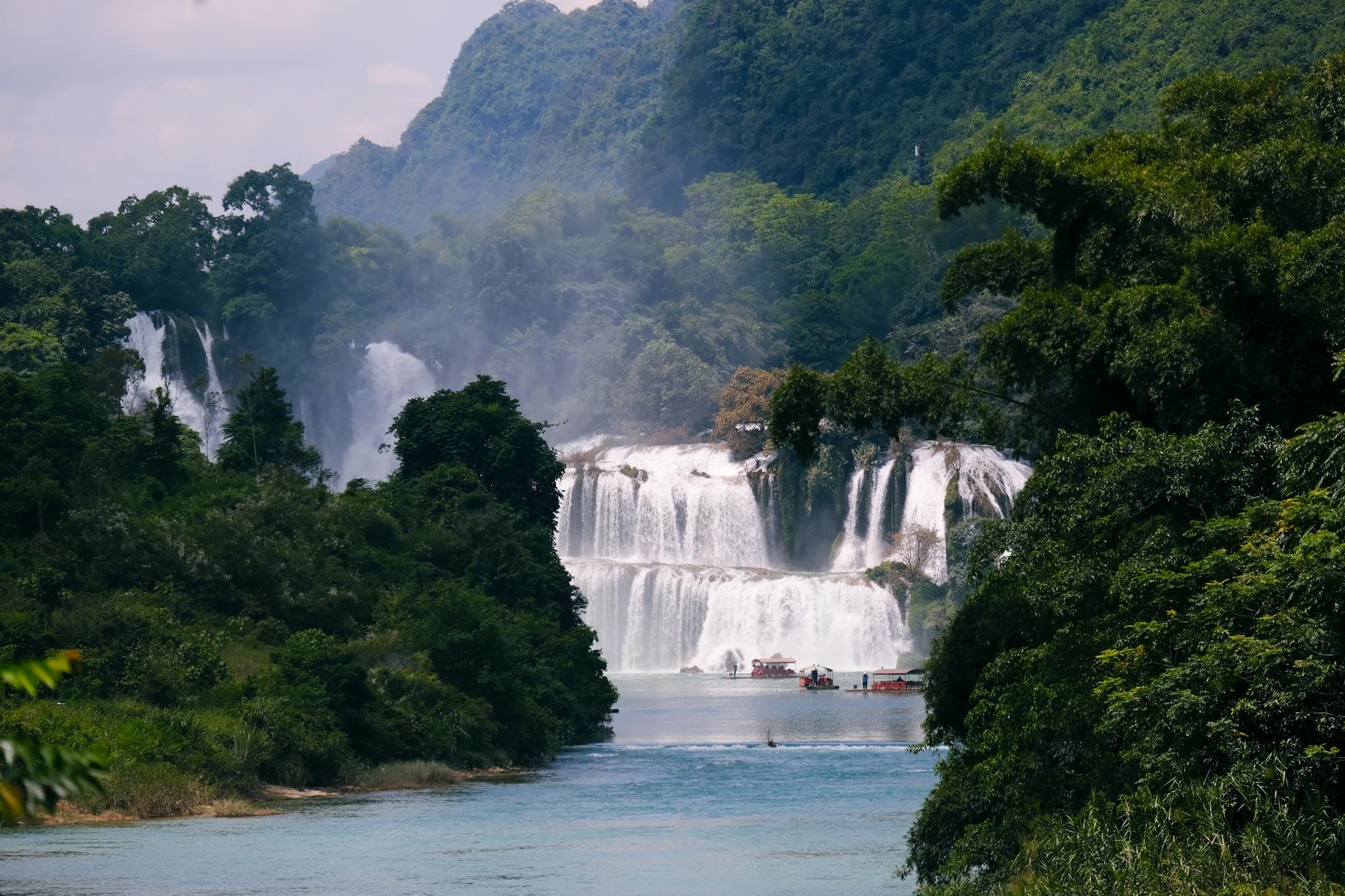
85 km: Ban Gioc Waterfall. GPS: 22.9185° N, 106.7185° E. Entrance fee: 45,000 VND ($1.80 USD). Boat ride: 50,000 VND ($2 USD). The waterfall is 53 meters high and 300 meters wide. It straddles the Vietnam-China border. The best views are from the Vietnamese side. The boat ride takes you close to the waterfall base. Expect to get wet.
Road condition note: The road is fully paved but narrow in sections. Livestock occasionally crosses without warning. Reduce speed in village areas. Fuel stations are available in Quang Uyen town at the 40 km mark. Fill up before continuing.
Route 2 detailed: Adding Phong Nam Valley and God's Eye
This extends Route 1 with a detour through Phong Nam Valley and the God's Eye (Mat Than) viewpoint.
After visiting Ban Gioc, return 10 km toward Cao Bang. Turn at the Phong Nam Valley sign. The road is well-maintained with rice terraces and water buffalo. Drive 15 km through the valley.
God's Eye viewpoint. GPS: 22.8334° N, 106.5812° E. Free. Requires a steep 500-meter walk up a gravel road. The view is a circular lake surrounded by limestone cliffs. Best visited in late afternoon for photography. The access road becomes impassable after heavy rain.
Thang Hen Lake. GPS: 22.8317° N, 106.5783° E. Entrance fee: 30,000 VND ($1.20 USD). Located 10 minutes from God's Eye. A peaceful lake with clear water. Swimming is allowed. Small restaurants nearby serve freshwater fish.
Return to Cao Bang via a different route through Đàm Thủy village. This road is less traveled and offers different scenery. The total distance for Route 2 is 220 km.
For budget planning, see: How much does a Cao Bang loop cost? A complete 2026 budget breakdown.
Route 3 detailed: The full Geopark experience including Me Pia Pass
This ambitious 4-day route covers the entire Non Nuoc Cao Bang Geopark.
Day 1: Cao Bang to Ban Gioc (same as Route 1). Overnight near the waterfall.
Day 2: Ban Gioc to Me Pia Pass area. 120 km, 4-5 hours. The road is winding but paved. The famous "slinky road" viewpoint requires a 30-minute hike from a small parking area. GPS: 22.5632° N, 106.1847° E. Free. Overnight in Nguyên Bình town.
Day 3: Me Pia Pass exploration and return toward Cao Bang. Visit Phia Oac-Phia Den National Park. The park has hiking trails and a waterfall. Entrance fee: 40,000 VND ($1.60 USD). Overnight in Nguyên Bình or return to Cao Bang.
Day 4: Remaining sights and return to Cao Bang. Visit Pac Bo Cave (where Ho Chi Minh lived in 1941). GPS: 22.7421° N, 106.4285° E. Entrance fee: 20,000 VND ($0.80 USD). Then return to Cao Bang city.
Honest assessment: Me Pia Pass is 2-3 hours from Ban Gioc. The road is winding but paved. This route is best for riders with at least 6 months of experience on Vietnamese roads. Driving times are typically 50-100% longer than Google Maps estimates.
When to ride the loop: Seasonal considerations
| Month | Temperature range | Rainfall | Road condition | Waterfall flow | Crowd level |
|---|---|---|---|---|---|
| October-April | 5-25°C (41-77°F) | Low | Excellent | Low | Low |
| December-February | 5-15°C (41-59°F) | Very low | Excellent | Very low | Very low |
| May-September | 20-35°C (68-95°F) | High | Variable | High | Low |
| July-August | 25-35°C (77-95°F) | Very high | Risk of landslides | Highest | Low |
| September-October | 20-30°C (68-86°F) | Moderate | Good | High | Medium |
October-April (dry season). Best roads and clearest views. Cold from December-February (5-15°C). Pack warm layers and rain gear. The cold is manageable with proper clothing.
May-September (rainy season). Green landscapes and fewer tourists. But risk of landslides on mountain passes, especially July-August. Check local weather forecasts before departing. The God's Eye access road becomes impassable after heavy rain.
September-October. Golden rice harvest season. Ideal for photography. Ban Gioc Waterfall has highest flow from August-October due to dam releases.
For more on weather planning, read: The Best and Worst Months to Visit Vietnam: A Region-by-Region Guide.
Safety and practical tips for the Cao Bang Loop
Fuel. Stations are available in Cao Bang city, Quang Uyen, and Trung Khanh. Between these points, carry extra fuel. A 1-liter bottle is sufficient for emergencies. Fill up whenever you see a station.
Phone reception. Viettel has the best coverage in remote areas. Download offline maps before departure. Google Maps and Maps.me work well offline.
Accidents. The nearest hospital with trauma care is in Cao Bang city. For serious injuries, evacuation to Hanoi is required. Travel insurance with helicopter evacuation coverage is strongly recommended. See: Medical Emergencies in Vietnam's Big Cities: What Travelers Need to Know.
Police checkpoints. Rare but possible near the Chinese border. Carry your passport at all times. International driving permits are not valid in Vietnam despite what you may read online.
Wild animals. Dogs and cattle frequently cross roads without warning. Reduce speed in village areas. Hit a dog and you will face angry locals. Hit a cow and you could be seriously injured.
Mosquitoes. Present year-round in lowland areas. Use repellent. For the risk assessment, read: Mosquitoes, Dengue and Malaria in Vietnam: The Realistic Risk Map for Travelers.
Warning: Do not ride after dark. Roads are unlit. Livestock and pedestrians are hard to see. Accidents are more common at night. Plan to arrive at your accommodation before sunset.
Where to stay along the loop
Cao Bang city. Mid-range hotels cost 300,000-600,000 VND ($12-25 USD) per night. Homestays cost 150,000-300,000 VND ($6-12 USD). The city has the widest range of options. Book ahead during October-April peak season.
Near Ban Gioc Waterfall. Homestays in Khuoi Ky stone village cost 200,000-400,000 VND ($8-16 USD) per night. Most include dinner for an additional 50,000-100,000 VND ($2-4 USD). Staying here allows you to visit the waterfall early in the morning before crowds arrive.
Phong Nam Valley. Phong Nam Station and similar homestays cost 250,000-500,000 VND ($10-20 USD) per night. The valley is quieter than Ban Gioc. Rice terrace views are excellent.
Me Pia Pass area. Limited options. Mostly basic homestays in Nguyên Bình town. Costs 150,000-300,000 VND ($6-12 USD) per night. Amenities are basic. Bring your own toilet paper and towel.
What to eat on the loop
Cao Bang city. Try phở chua (sour noodle soup), bánh cuốn (steamed rice rolls), and thịt vịt quay (roast duck). Street food stalls are concentrated around the central market.
Trung Khanh district. Trung Khanh chestnuts are seasonal from September to November. Roasted or boiled, they are a local specialty.
Ban Gioc area. Freshwater fish from the Quây Sơn River. Grilled or steamed, served with rice and herbs.
Village markets. Look for xôi (sticky rice) and grilled meats for quick meals. Small roadside eateries exist but may not have English menus. Google Translate with the camera function is essential.
For more on eating safely, read: Vietnamese Street Food Safety: How to Eat Everywhere Without Getting Sick.
How many days do you actually need?
1 day. Possible but rushed. Only Ban Gioc Waterfall and immediate return. 6+ hours of driving. Not recommended.
2 days. Minimum for a comfortable experience. Route 1 with overnight near Ban Gioc. You have time for the waterfall, cave, and viewpoints.
3 days. Recommended for most travelers. Route 2 with Phong Nam Valley and God's Eye. You can take your time and enjoy the scenery.
4 days. For the full Geopark experience including Me Pia Pass. This allows for rest days and exploration of remote areas.
Honest assessment: Most travelers underestimate driving time. A 2-hour Google Maps estimate often takes 3-4 hours on mountain roads. Add 50% to your planned driving time.
Cao Bang Loop vs. Ha Giang Loop: Which should you choose?
| Feature | Cao Bang | Ha Giang |
|---|---|---|
| Distance | 170-350 km | 300-450 km |
| Days needed | 2-4 days | 5-7 days |
| Difficulty | Easy-moderate | Moderate-hard |
| Scenery | Karst, waterfalls, valleys | Mountain passes, rice terraces |
| Crowds | Low | Medium-high |
| Road quality | Good pavement | Good pavement with some rough sections |
| Cost per day | 500,000-800,000 VND ($20-33 USD) | 600,000-1,000,000 VND ($25-40 USD) |
Cao Bang is better for travelers with limited time (3-4 days) or less motorbike experience. Ha Giang is more dramatic but requires 5-7 days and more riding confidence.
For a full comparison, read: Ha Giang Loop: The Honest 2026 Guide.
FAQ
Q: Is the Cao Bang Loop safe for beginner motorbike riders? A: Not recommended for complete beginners. The roads are paved but steep, winding, and occasionally narrow with blind corners. First-time riders should hire an easy rider or use a car with driver. At minimum, riders should have 3+ months of experience on similar roads.
Q: How long does it take to drive the Cao Bang Loop? A: The shortest route (Cao Bang to Ban Gioc and back) takes 2 days comfortably. The extended loop including Phong Nam Valley takes 3 days. The full Geopark loop including Me Pia Pass requires 4 days. Driving times are typically 50-100% longer than Google Maps estimates.
Q: Can you do the Cao Bang Loop without a motorbike? A: Yes. Cars with drivers can be hired in Cao Bang city for 800,000-1,200,000 VND per day. Some viewpoints with steep gravel access roads (like God's Eye) may be inaccessible by car. Organized tours are also available but not recommended by this guide.
Q: What is the best time of year for the Cao Bang Loop? A: October to April offers the best road conditions and clearest views. September-October adds golden rice terraces. August-October has the highest waterfall flow at Ban Gioc. December-February is cold (5-15°C) but clear. May-September has green landscapes but risk of landslides.
Q: Do I need a guide for the Cao Bang Loop? A: No, the routes are straightforward with paved roads and clear signage. Offline maps (Google Maps or Maps.me) work well. A guide is only necessary for travelers who want cultural interpretation or who are not confident navigating independently.
Q: Can I combine the Cao Bang Loop with the Ha Giang Loop? A: Yes. The drive from Ha Giang city to Cao Bang takes 4-5 hours via Khau Coc Cha Pass. This requires a minimum of 7-8 days total for both loops. Most travelers do one or the other, not both, due to time constraints.
Q: What should I pack for the Cao Bang Loop? A: Rain gear (even in dry season), warm layers (November-February), offline maps, a physical map as backup, cash (ATMs are scarce outside Cao Bang city), basic first aid kit, sun protection, and a reusable water bottle. Phone charger with a power bank is essential.