What you need to know before going
Cao Bang province sits in Northeast Vietnam, sharing a long border with China. The loop winds through limestone karst landscapes, river valleys, and remote ethnic minority villages. The full circuit covers approximately 250-300 km depending on your chosen route and side trips.
Most riders complete the loop in 3-4 days. The terrain is less extreme than Ha Giang but still demands respect. You will encounter steep mountain passes, tight switchbacks, and sections of unpaved road. This loop suits riders with some experience on a motorbike. Complete beginners should consider hiring an easy rider.
Cao Bang differs from Ha Giang in several key ways. Traffic is lighter. Tourism infrastructure is less developed. English is spoken less frequently. The attractions are more spread out. The payoff is a more authentic experience with fewer crowds.
Pro tip: Download offline maps on Google Maps before you go. Mobile reception is patchy in the mountains, especially on the southern border route.
Cao Bang Loop vs Ha Giang Loop: Which one should you choose?
This is the most common question travelers ask. Here is a direct comparison.
| Factor | Cao Bang Loop | Ha Giang Loop |
|---|---|---|
| Road difficulty | Moderate, one rough section | Moderate to hard, consistently challenging |
| Traffic volume | Low, few tour buses | Medium, many tour groups and easy riders |
| Scenery type | Waterfalls, caves, rivers, karst | Deep mountain passes, terraced rice fields |
| Tourism infrastructure | Developing, basic options | Well-established, many choices |
| Unique attractions | Ban Gioc Waterfall, Nguom Ngao Cave, Pac Bo historical site | Ma Pi Leng Pass, Dong Van Karst Plateau, Lung Cu Flag Tower |
| Crowd levels | Quiet, even in peak season | Busy in peak season (October, March) |
| Time needed | 3-4 days | 4-5 days |
Choose Cao Bang if: You prefer waterfalls and caves over mountain passes. You want quieter roads. You have 3-4 days. You are interested in Vietnam-China border history. You want a less touristy experience.
Choose Ha Giang if: You want the most dramatic mountain scenery in Vietnam. You enjoy social travel with other riders. You have 4-5 days. You want established accommodation and food options. You are an experienced rider looking for a challenge.
Read more: For a detailed comparison of crowds and development, see Is Cao Bang touristy? An honest look at crowds, development, and what to expect in 2026.
Best time to drive the Cao Bang Loop
Weather dictates road safety on this loop. Rain turns unpaved sections into mud slides. Fog reduces visibility on mountain passes to near zero.
| Month | Avg temp (°C) | Rainfall | Road condition | Scenery highlights | Crowd level |
|---|---|---|---|---|---|
| January | 12-18 | Low | Good, cold | Clear views, misty mornings | Low |
| February | 14-20 | Low | Good | Peach blossom season | Low |
| March | 16-24 | Low | Good | Spring flowers, warming weather | Medium |
| April | 20-28 | Moderate | Good | Green landscapes | Medium |
| May | 24-32 | High | Fair, slippery | Waterfalls at peak flow | Low |
| June | 26-34 | Very high | Poor, landslide risk | Lush green, but hazardous | Low |
| July | 26-34 | Very high | Poor | Rice planting season | Low |
| August | 25-32 | Very high | Poor | Rain, leeches, mud | Low |
| September | 22-30 | High | Fair | Golden rice terraces | Medium |
| October | 18-26 | Low | Good | Harvest season, clear skies | High |
| November | 14-22 | Low | Good | Dry roads, cool weather | Medium |
| December | 10-18 | Low | Good | Cold, clear, quiet | Low |
The best window: October to April. Roads are dry. Skies are clear. Temperatures are comfortable for riding. December and January can drop to 5°C at higher elevations. Pack warm layers.
The worst window: June to August. Heavy rain causes landslides. The southern border route becomes treacherous. Leeches are common in wet areas. Visibility drops sharply.
Pro tip: For more on traveling during wet months, read Vietnam Rainy Season Travel: Honest Tips for Monsoon Months.
How to get to Cao Bang
Cao Bang city is the starting point for the loop. It sits about 270 km from Hanoi.
From Hanoi by bus: Sleeper buses depart from My Dinh bus station and Giap Bat bus station. Travel time is 6-7 hours. Tickets cost 200,000-350,000 VND ($8-14 USD). Buses run overnight and early morning. Companies like Hung Thanh and Bang Phuc operate this route. Book through your hotel or a bus booking website.
From Hanoi by minivan: Limousine minivans offer a faster, more comfortable option. Travel time is 5-6 hours. Tickets cost 350,000-500,000 VND ($14-20 USD). These depart from Hanoi's Old Quarter.
From Ha Giang: If you are combining loops, the direct route takes 4-5 hours by motorbike via QL34. The road is paved but winding. Buses also run this route but require a transfer in Bac Kan.
Transporting your motorbike: Buses charge 100,000-200,000 VND ($4-8 USD) extra for a motorbike in the cargo hold. Some companies refuse large bikes. Confirm when booking.
Read more: For bus options to northern destinations, see Hanoi to Ha Giang: 3 Routes Compared (Sleeper Bus, Limousine Van, Private Car).
Renting a motorbike in Cao Bang: What you need to know
Several rental shops operate in Cao Bang city. Most are near the bus station or along Kim Dong Street. The Loop Cao Bang and Mr Linh's Adventure are established options. Bong Backpacker Hostel also rents bikes to guests.
Rental prices: 150,000-300,000 VND ($6-12 USD) per day. Semi-automatic bikes (Honda Wave, Yamaha Sirius) cost 150,000-200,000 VND. Manual bikes (Honda XR150, Yamaha Exciter) cost 200,000-300,000 VND.
Deposit: 5-10 million VND ($200-400 USD) in cash. Some shops accept passport as collateral. Avoid leaving your passport if possible. Negotiate a cash deposit instead.
Bike types: A 125cc semi-automatic or manual bike is the minimum for this loop. Automatic scooters (110cc) struggle on the steep climbs of the southern border route. They also lack engine braking on descents. Rent a proper bike.
Inspection checklist:
- Check tire tread and pressure
- Test front and rear brakes
- Check chain tension and lubrication
- Test all lights and horn
- Check engine oil level
- Look for leaks under the bike
- Test the horn works
Warning: Many rental bikes have worn brake pads. Ask the shop to show you the pads before you leave. Replace them if they look thin. This could save your life on a mountain descent.
Documentation: Technically, Vietnam requires an International Driving Permit (IDP) for foreign riders. In practice, many rental shops do not check. Police checks do occur near Cao Bang city. Fines for driving without a valid license are 800,000-1,500,000 VND ($32-60 USD). For the full legal picture, read Renting a Motorbike in Vietnam: The Legal Truth Nobody Tells Tourists.
The complete Cao Bang Loop route: 3-day itinerary
This itinerary covers the main loop with one alternative routing option. Distances and driving times are estimates. Add 30-50% more time for photo stops and breaks.
Day 1: Cao Bang to Ban Gioc Waterfall (85 km, 2.5-3 hours)
Route: QL3 north, then TL206 east.
Leave Cao Bang city in the morning. Fill your tank at the Petrolimex station on the northern edge of town. This is the last reliable gas station until Ban Gioc.
The road follows the Bang Giang River through flat farmland. After 30 km, turn east onto TL206. The road climbs into limestone hills. Stop at Phuc Sen blacksmithing village (15 km from the turn). Local Nung An ethnic minority people forge farming tools by hand. Watch the demonstration. Buy a small knife as a souvenir if you want.
Continue to Bo Hay viewpoint (45 km from Cao Bang). The view overlooks a winding river through karst peaks. The road surface here is paved but narrow. Watch for oncoming trucks.
Arrive at Nguom Ngao Cave (5 km before Ban Gioc). Entrance fee is 45,000 VND ($1.80 USD). The cave runs 3 km with lit walkways. Allow 45 minutes. The formations are impressive but less developed than Phong Nha. For a comparison of cave experiences, read Which cave is best to visit in Phong Nha?.
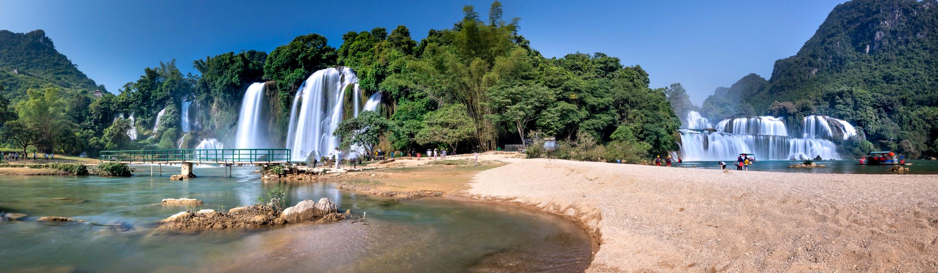
Finish at Ban Gioc Waterfall. Entrance fee is 45,000 VND ($1.80 USD). The waterfall is 300 meters wide and drops 30 meters. It sits directly on the Chinese border. You can see Chinese tourists on the opposite side. A bamboo raft ride costs 50,000 VND ($2 USD) and gets you close to the main cascade.
Overnight near Ban Gioc. Homestays cluster along the road to the waterfall. Prices range from 150,000-400,000 VND ($6-16 USD) per night.
Pro tip: Visit Ban Gioc in the late afternoon. The light is better for photos. The crowds from day trips have left. The waterfall is quieter.
Day 2: Ban Gioc to Tra Linh (80 km, 3-4 hours)
This is where you choose your route.
Option A: The easy return (via QL3) Return to Cao Bang via the same road you came. Continue south on QL3 to Tra Linh. Total distance is 95 km. Driving time is 2.5 hours. The road is fully paved. This is the safe choice for inexperienced riders.
Option B: The adventurous southern border route (via TL206/207) This is the rougher but more scenic option. From Ban Gioc, continue east on TL206. The road follows the Chinese border through remote villages. After 25 km, turn south onto TL207.
This section is the most challenging on the loop. The road surface varies from packed dirt to loose gravel to broken asphalt. Sections become impassable after heavy rain. Landslides are common in wet season. Allow 3-4 hours for 55 km.
The payoff is spectacular. You ride through Phong Nam valley with karst peaks on both sides. Few tourists use this road. You will pass through Tay and Nung villages where children wave and adults stare.
Stop at Ho Thang Hen Lake (on TL207, 40 km from Ban Gioc). This emerald green lake sits in a sinkhole surrounded by cliffs. A homestay here offers basic rooms for 150,000 VND ($6 USD). The owner can cook dinner for 50,000 VND ($2 USD).
Continue to Tra Linh town. Accommodation options are basic. Guesthouses cost 150,000-250,000 VND ($6-10 USD) per night. There are no hotels above 3 stars.
Warning: The southern border route (TL206/207) is not suitable for automatic scooters or inexperienced riders. If you have any doubts about your ability, take Option A. For a full safety assessment, read Is the Cao Bang Loop safe to drive?.
Day 3: Tra Linh to Pac Bo to Cao Bang (95 km, 3-4 hours)
Route: TL210 north, then TL203 west.
Leave Tra Linh in the morning. Fill up at the small gas station in town. The next reliable fuel is in Cao Bang.
Take TL210 north toward the Chinese border. The road climbs through forested hills. After 30 km, you reach the Khau Coc Cha Pass. The road snakes up a steep mountainside with tight switchbacks. The surface is paved but narrow. Watch for trucks carrying timber.
Descend into the Pac Bo valley. This area holds historical significance. Ho Chi Minh lived here in 1941 after returning from 30 years abroad. Visit Pac Bo Cave (free entry). The cave is small but historically important. Lenin Stream and Karl Marx Mountain sit nearby. The names were chosen by Ho Chi Minh himself.
From Pac Bo, take TL203 south back to Cao Bang city. The road follows a river valley through rice paddies. The surface is good. Driving time is 1.5 hours.
Arrive in Cao Bang by late afternoon. Return your rental bike. Celebrate with a cold beer at a lakeside cafe.
Pro tip: If you have a fourth day, add a side trip to Phia Thap incense village (30 km south of Cao Bang). Local families make incense sticks by hand. The colorful drying racks make great photos.
Road conditions and safety: What nobody tells you
The Cao Bang Loop is safer than Ha Giang but still presents real risks. Here is the honest assessment.
QL3 (Cao Bang to Ban Gioc): Good condition. Paved, wide enough for two cars. Watch for livestock on the road. Cows and water buffalo wander freely. Trucks from China use this road at all hours. They drive fast and do not slow down for motorbikes.
TL206 (Ban Gioc to southern border): Fair condition near Ban Gioc. Poor condition east of Ban Gioc. Unpaved sections with loose gravel. Narrow in places. No guardrails on mountain sections.
TL207 (Southern border route): Poor to very poor condition. Loose gravel, potholes, mud. Sections wash out in rain. No street lights. No phone reception. If you break down here, you walk to find help.
TL210 (Tra Linh to Pac Bo): Good condition. Paved but narrow. Steep gradients on Khau Coc Cha Pass. Use engine braking on descents. Do not ride the brakes.
TL203 (Pac Bo to Cao Bang): Good condition. Flat river valley road. Easy riding.
Common hazards:
- Livestock on roads at all hours
- Trucks from China that do not yield
- Loose gravel on corners, especially on TL207
- Sudden fog that reduces visibility to 10 meters
- Rain that turns dust to grease on unpaved sections
Emergency planning:
- Save the Cao Bang tourist police number: +84 206 3852 462
- Download the Vietnam SOS app for emergency contacts
- Carry a basic tool kit and tire repair kit
- Know that the nearest hospital with English-speaking staff is in Cao Bang city
Read more: For a country-wide safety overview, see Is Vietnam Safe in 2026? An Honest Country-Wide Risk Assessment.
What to pack for the Cao Bang Loop
Essential documents:
- Passport (original, not a copy)
- Driving license and IDP
- Rental agreement
- Insurance documents
- Cash (ATMs are rare outside Cao Bang city)
Riding gear:
- Helmet (provided by rental, but bring your own if you have one)
- Lightweight jacket for sun protection
- Rain jacket (mandatory, even in dry season)
- Warm layer for mountain passes (fleece or thermal)
- Gloves
- Sunglasses or clear glasses for wind
- Bandana or buff for dust
Tools and spares:
- Tire repair kit with tire levers
- Mini pump or CO2 inflator
- Multi-tool
- Zip ties (fix anything temporarily)
- Brake pads (ask your rental shop for spares)
- Clutch cable (ask your rental shop for spares)
Health and safety:
- First aid kit with antiseptic, bandages, painkillers
- Insect repellent with DEET
- Sunscreen (SPF 50+)
- Rehydration salts
- Antibacterial wipes
Navigation:
- Offline Google Maps on your phone
- Physical map as backup
- Power bank (no charging points on the road)
- USB cable for your phone
Pro tip: For mosquito prevention and health risks, read Mosquitoes, Dengue and Malaria in Vietnam: The Realistic Risk Map for Travelers.
Where to stay on the loop
| Location | Type | Price range | Booking needed? | Notes |
|---|---|---|---|---|
| Cao Bang city | Mid-range hotel | 300,000-500,000 VND | Recommended | Best facilities, restaurants nearby |
| Cao Bang city | Hostel | 100,000-200,000 VND | Walk-in OK | Dorm beds, social atmosphere |
| Near Ban Gioc | Homestay | 150,000-400,000 VND | Recommended in peak season | Family-run, basic but clean |
| Near Ban Gioc | Saigon Ban Gioc Resort | 800,000-1,500,000 VND | Essential | Only upscale option, has pool |
| Tra Linh | Guesthouse | 150,000-250,000 VND | Walk-in OK | Very basic, shared bathroom |
| Thang Hen Lake | Homestay | 150,000 VND | Walk-in OK | Remote, no English, book through your hotel |
Eating and drinking on the loop
Local specialties in Cao Bang province include:
Roasted duck with seven flavors (vit quay bay vi): The signature dish of Cao Bang. Duck is marinated in seven spices and roasted until the skin is crispy. Served with rice paper and fresh herbs. Find it in restaurants along Kim Dong Street in Cao Bang city. Cost: 80,000-120,000 VND ($3.20-4.80 USD).
Sour noodles (banh da chua): A local noodle soup with a sour broth made from fermented rice. Topped with pork, herbs, and crushed peanuts. Available at street stalls in Cao Bang city. Cost: 20,000-30,000 VND ($0.80-1.20 USD).
Ant egg cakes (banh trung kien): A Tay ethnic minority specialty. Sticky rice cakes filled with ant eggs and sesame. The eggs have a nutty flavor. Available at markets near Ban Gioc. Cost: 5,000-10,000 VND each.
Cao Bang sausage (lap xuong Cao Bang): Dried pork sausage with a smoky flavor. Good for snacking on the road. Buy from markets. Cost: 50,000-80,000 VND per string.
For vegetarian travelers: Options are limited outside Cao Bang city. Buddhist temples sometimes offer simple vegetarian meals. Pack instant noodles and protein bars as backup. For street food safety tips, read Vietnamese Street Food Safety: How to Eat Everywhere Without Getting Sick.
Costs: How much to budget for a self-drive
| Item | Budget option | Mid-range option | Notes |
|---|---|---|---|
| Bike rental | 150,000 VND/day | 250,000 VND/day | Semi-auto vs manual |
| Fuel | 150,000-200,000 VND total | Same | Full loop on one tank |
| Accommodation | 150,000 VND/night | 400,000 VND/night | Homestay vs hotel |
| Food | 100,000 VND/day | 250,000 VND/day | Street food vs restaurant |
| Entrance fees | 135,000 VND total | Same | Ban Gioc + Nguom Ngao |
| Parking | 10,000-20,000 VND per stop | Same | At attractions |
| Miscellaneous | 100,000 VND | 200,000 VND | Water, snacks, tips |
Total for 3 days self-drive: 1,500,000-2,500,000 VND ($60-100 USD) per person.
Read more: For a detailed cost breakdown, see How much does a Cao Bang loop cost? A complete 2026 budget breakdown.
Should you hire an easy rider instead?
| Factor | Self-drive | Easy rider | Best for |
|---|---|---|---|
| Freedom | Full control of pace and stops | Limited to rider's schedule | Self-drive |
| Safety | Depends on your skill | Local knows the roads | Easy rider |
| Cost | 150,000-250,000 VND/day | 300,000-500,000 VND/day | Self-drive |
| Navigation | You figure it out | No navigation needed | Easy rider |
| Local knowledge | Limited | Rider knows good spots | Easy rider |
| Physical effort | High | Low | Easy rider |
| Social interaction | Solo or with your group | With your rider | Both |
Hire an easy rider if:
- You have no motorbike experience
- You are not confident on mountain roads
- You want to focus on scenery, not driving
- You are traveling solo and want company
- You have a bigger budget
Drive yourself if:
- You have motorbike experience
- You want complete freedom
- You are on a tight budget
- You enjoy the challenge of navigation
- You are traveling with a group of friends
Pro tip: If you hire an easy rider, negotiate the price upfront. Include meals and accommodation for the rider in the deal. Standard practice is to cover the rider's food and bed.
Responsible travel on the Cao Bang Loop
Cao Bang province is a UNESCO Global Geopark. This status recognizes the geological and cultural value of the area. Visitors have a responsibility to protect it.
Stay on marked roads. Off-road riding damages fragile ecosystems and disturbs local communities. The limestone karst landscape is sensitive to erosion.
Do not disturb local communities. Ask permission before taking photos of people. Do not enter homes without an invitation. Learn a few words of Tay or Nung language. A simple "xin chao" (hello) goes a long way.
Proper waste disposal. Carry a plastic bag for your trash. Do not throw bottles or wrappers on the road. Many rural areas have no waste collection system. Your trash becomes someone else's problem.
Respect cultural sites. Dress modestly at Pac Bo Cave and other historical sites. Do not touch or remove artifacts. Do not climb on statues or monuments.
Support local businesses. Buy snacks from village shops. Eat at family-run restaurants. Stay at homestays rather than chain hotels. Your money directly supports the local economy.
Read more: For broader tips on traveling responsibly in Vietnam, see Tipping in Vietnam 2026: When It's Insulting, When It's Expected.
FAQ
Q: How difficult is the Cao Bang Loop? A: The loop is moderately difficult. Main roads (QL3, TL203, TL210) are well-paved with steep sections and tight corners. The southern border route (TL206/207) includes rough unpaved sections that require experience. Overall, it is easier than the Ha Giang Loop but still requires confidence on a motorbike.
Q: How much does a Cao Bang Loop cost? A: For a 3-day self-drive trip, budget approximately 1,500,000-2,500,000 VND ($60-100 USD) per person including bike rental, fuel, accommodation, food, and entrance fees. Hiring an easy rider adds 300,000-500,000 VND per day.
Q: Is the Cao Bang Loop safe to drive? A: Generally safe on main roads during dry season, but risks include livestock on roads, trucks from China, loose gravel on corners, and sudden weather changes. The southern border route has genuine safety concerns due to poor road conditions. Travelers should have motorbike experience, wear proper gear, and avoid night driving.
Q: Is Ha Giang or Cao Bang better? A: Ha Giang offers more dramatic mountain passes and established tourism infrastructure. Cao Bang provides quieter roads, unique attractions (Ban Gioc Waterfall, historical sites), and a more relaxed experience. Choose Ha Giang for adrenaline and social travel. Choose Cao Bang for waterfalls, history, and solitude.
Q: How many days do you need for the Cao Bang Loop? A: Three days is the minimum for the main loop. Four days allows for side trips (Thang Hen Lake, Phia Thap incense village) and a more relaxed pace. Two days is possible but rushed and not recommended.
Q: Do I need an international driving permit for Vietnam? A: Technically yes. Vietnam requires an International Driving Permit (IDP) for foreign riders. In practice, many rental shops do not check, but police checks do occur, especially near Cao Bang city. Fines for driving without a valid license are 800,000-1,500,000 VND ($32-60 USD).
Q: Can I do the Cao Bang Loop on a scooter? A: A 125cc semi-automatic or manual bike is recommended for the steep mountain roads. Automatic scooters (110cc) can manage the main roads but struggle on the steeper sections of the southern border route and the climb to Angel Eye Mountain.
Q: What is the best time of year for the Cao Bang Loop? A: October to April offers the best conditions: dry roads, clear views, and comfortable temperatures. September is ideal for golden rice terraces. June to August brings heavy rain, landslides, and leeches. December to February can be very cold (5-15°C) but offers clear skies.