Malaria and dengue risk map of Vietnam
Where malaria is still transmitted in Vietnam, and where it is not, on one map: the forested border and highland districts where local cases still occur, the rural hill areas where cases are rare, and the cities, deltas and coastal plains that are malaria-free. Dengue, carried by a different mosquito, occurs in every region, year-round in the south and mostly from June to November in the north. The map summarises CDC, WHO and Vietnamese Ministry of Health guidance; it is not medical advice, so check your itinerary with a travel clinic before you leave.


Free for personal use · PDF · PNG · SVG
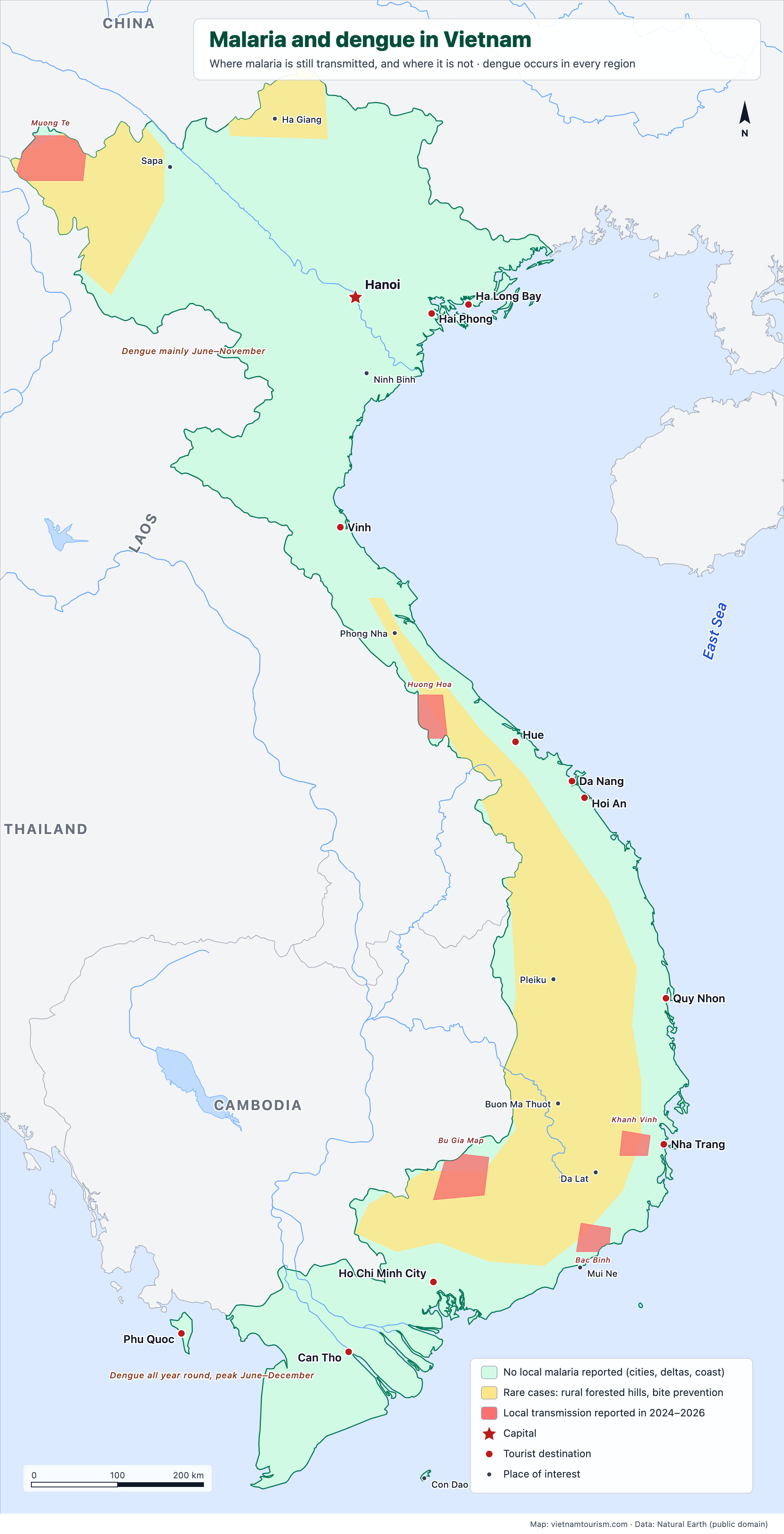
How to read the map. Green: no local malaria is reported in the cities, the Red River and Mekong deltas, the coastal plain north of Nha Trang, Phu Quoc and the provinces Vietnam has recognised as malaria-free (48 of the 63 former provinces by 2025). Yellow: rural, forested hills where cases are rare; the UK advises bite prevention only, the US CDC still recommends antimalarial tablets for the Central Highlands and nearby provinces. Red: the districts where local transmission was reported between 2024 and 2026, in Khanh Vinh (inland from Nha Trang), Huong Hoa (Quang Tri, Lao border), Muong Te (Lai Chau), Bac Binh (Binh Thuan) and the Bu Gia Map forests of Binh Phuoc. Vietnam counted 353 malaria cases in 2024 and 246 in 2025, none fatal, most of them among forest workers and people returning from Africa. Dengue is the real risk for travellers: about 185,000 cases in 2025, three quarters of them in the south, where it circulates all year with a peak from June to December; in the north the season runs from June to November. Sources: CDC Yellow Book 2026, UK TravelHealthPro, WHO World Malaria Report 2025, WHO Western Pacific dengue updates, Vietnam Ministry of Health and NIMPE (2025–2026).
What's on the map
- No local malaria reported (cities, deltas, coast)
- Rare cases: rural forested hills, bite prevention
- Local transmission reported in 2024–2026
- Hanoi
- Hai Phong
- Ha Long Bay
- Sapa
- Ha Giang
- Ninh Binh
- Vinh
- Phong Nha
- Hue
- Da Nang
- Hoi An
- Quy Nhon
- Pleiku
- Buon Ma Thuot
- Nha Trang
- Da Lat
- Mui Ne
- Ho Chi Minh City
- Can Tho
- Phu Quoc
- Con Dao
Other maps
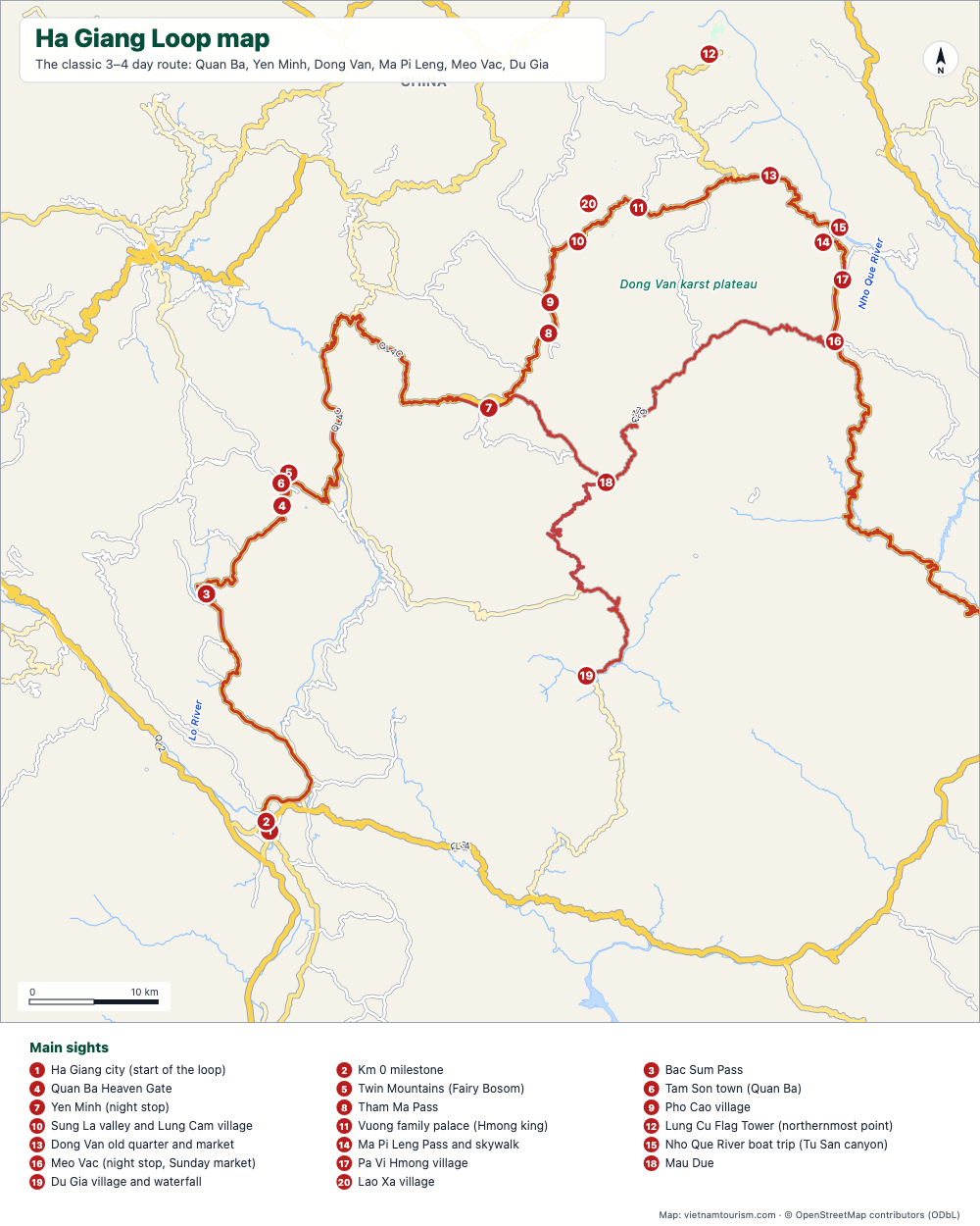
Ha Giang Loop map
Free printable map of the Ha Giang Loop: Ha Giang, Quan Ba, Yen Minh, Dong Van, Ma Pi Leng, Meo Vac, Du Gia, with the route highlighted, 20 numbered stops and the roads. PDF, PNG and SVG.
PDF · PNG · SVG
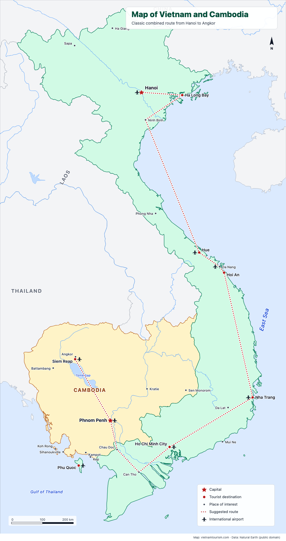
Map of Vietnam and Cambodia
Free printable map of Vietnam and Cambodia for a combined trip: Hanoi, Ha Long, Hue, Hoi An, Nha Trang, Saigon, Mekong, Phnom Penh, Siem Reap and Angkor, with the classic route drawn. PDF, PNG and SVG.
PDF · PNG · SVG
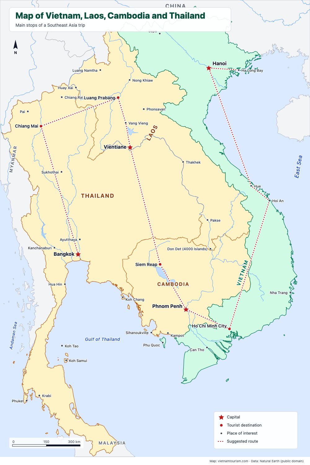
Map of Vietnam, Laos, Cambodia and Thailand
Free printable map of Vietnam, Laos, Cambodia and Thailand for a Southeast Asia trip: Bangkok, Chiang Mai, Luang Prabang, Vientiane, Siem Reap, Phnom Penh, Saigon, Hoi An, Hue, Hanoi, with a suggested route. PDF, PNG and SVG.
PDF · PNG · SVG
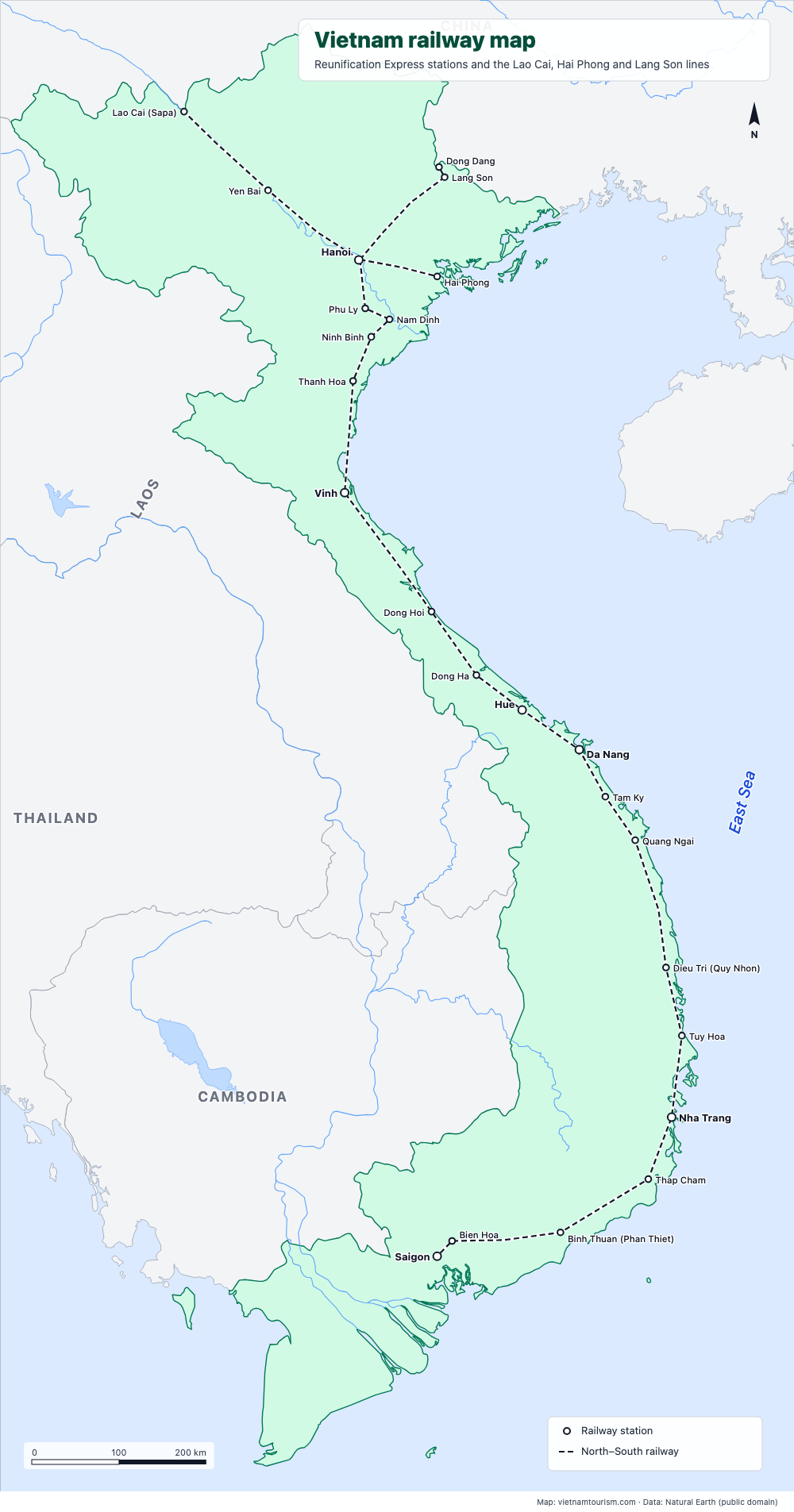
Vietnam railway map
Free printable railway map of Vietnam: the North–South line from Hanoi to Saigon with its 19 main stations, and the lines to Lao Cai (Sapa), Hai Phong and Lang Son. PDF, PNG and SVG.
PDF · PNG · SVG
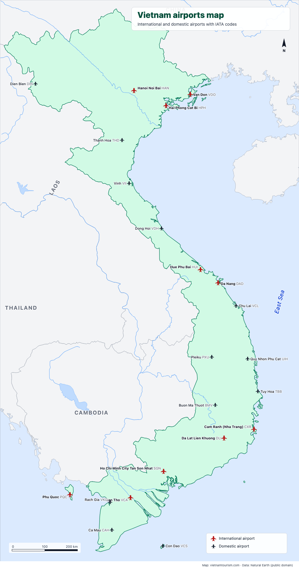
Vietnam airports map
Free printable map of Vietnam's airports: the 10 international airports (Hanoi, Ho Chi Minh City, Da Nang, Cam Ranh, Phu Quoc, Hue, Hai Phong, Van Don, Da Lat, Can Tho) and 12 domestic ones, with IATA codes. PDF, PNG and SVG.
PDF · PNG · SVG
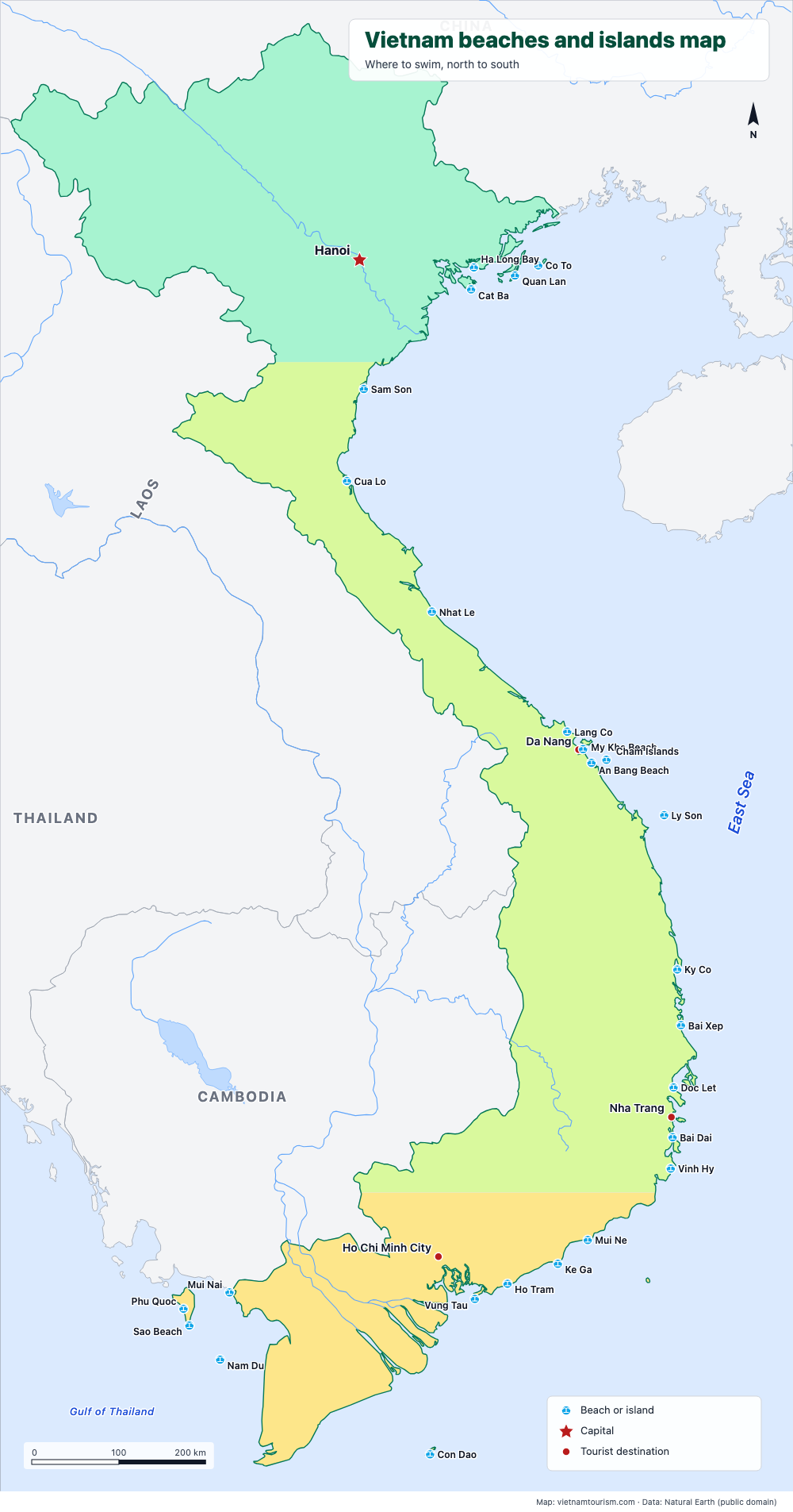
Vietnam beaches and islands map
Free printable map of Vietnam's beaches and islands: Cat Ba, Lang Co, My Khe, An Bang, Ly Son, Quy Nhon, Nha Trang, Mui Ne, Con Dao, Phu Quoc, Nam Du and 15 more, north to south. PDF, PNG and SVG.
PDF · PNG · SVG